Abstract
Research Article
Satellite-Based Analysis of Air Pollution Trends in Khartoum before and After the Conflict
Hossam Aldeen Anwer*, Abubakr Hassan and Ghofran Anwer
Published: 16 January, 2025 | Volume 9 - Issue 1 | Pages: 001-011
This study investigates the impact of socio-political disruptions on air quality in Khartoum, Sudan, focusing on key pollutants: Aerosol Optical Depth (AOD), Carbon Monoxide (CO), Nitrogen Dioxide (NO₂), and Sulfur Dioxide (SO₂). Using Sentinel-5P satellite data (2020–2024) processed in Google Earth Engine (GEE), spatial and temporal variations in pollutant levels were analyzed before and after a significant war event in April 2023. The methodology included data acquisition, preprocessing (e.g., cloud masking, spatial filtering), monthly averages computation, visualization, and statistical analysis using Google Earth Engine (GEE), ArcGIS Pro, and Microsoft Excel. Results showed a marked post-war increase in AOD levels, attributed to infrastructure destruction, fires, and diminished industrial oversight, alongside spatially consistent pollution patterns in some regions. CO concentrations exhibited an overall decline due to reduced industrial activities and transportation, though localized anomalies were linked to concentrated emissions. Similarly, NO₂ levels dropped significantly, reflecting reduced vehicular and industrial activities, while sporadic increases suggested localized emissions like generator use. SO₂ demonstrated mixed trends, with reduced mean levels but increased variability, indicating sporadic high-emission events linked to emergency fuel use or conflict-related disruptions. This study uniquely combines high-resolution satellite data with advanced spatial and temporal analysis techniques to reveal the nuanced and multi-pollutant impact of socio-political conflicts on air quality in Khartoum, providing novel insights into the environmental repercussions of armed conflicts. These findings highlight the profound impact of socio-political events on atmospheric pollution dynamics, underscoring the need for robust urban planning, targeted environmental monitoring, and policies to mitigate air quality deterioration and address public health concerns in conflict-prone regions. The study emphasizes the importance of satellite-based monitoring to provide critical insights into the environmental repercussions of socio-political upheavals.
Read Full Article HTML DOI: 10.29328/journal.acee.1001074 Cite this Article Read Full Article PDF
Keywords:
Air pollution; Environmental impact of war; Satellite remote sensing; Google Earth Engine (GEE); Sentinel-5P
References
- Hryhorczuk D, Levy BS, Prodanchuk M, Kravchuk O, Bubalo N, Hryhorczuk A, et al. The environmental health impacts of Russia’s war on Ukraine. J Occup Med Toxicol. 2024;19(1):1. Available from: https://occup-med.biomedcentral.com/articles/10.1186/s12995-023-00398-y
- Zalakeviciute R, Mejia D, Alvarez H, Bermeo X, Bonilla-Bedoya S, Rybarczyk Y, et al. War impact on air quality in Ukraine. Sustainability. 2022;14(21):13832. Available from: https://doi.org/10.3390/su142113832
- Abed Al Ahad M, Sullivan F, Demšar U, Melhem M, Kulu H. The effect of air-pollution and weather exposure on mortality and hospital admission and implications for further research: A systematic scoping review. PLoS One. 2020;15(10):e0241415. Available from: https://doi.org/10.1371/journal.pone.0241415
- Kazi Z, Filip S, Kazi L. Predicting PM2.5, PM10, SO2, NO2, NO and CO air pollutant values with linear regression in R language. Appl Sci. 2023;13(6):3617. Available from: https://doi.org/10.3390/app13063617
- Meo SA, Salih MA, Al-Hussain F, Alkhalifah JM, Meo AS, Akram A. Environmental pollutants PM2.5, PM10, carbon monoxide (CO), nitrogen dioxide (NO). Eur Rev Med Pharmacol Sci. 2024;28:789-96. Available from: https://doi.org/10.26355/eurrev_202401_35079
- Huang X. The impact of PM10 and other airborne particulate matter on the cardiopulmonary and respiratory systems of sports personnel under atmospheric exposure. Atmosphere. 2023;14(11):1697. Available from: https://doi.org/10.3390/atmos14111697
- Anwer HA, Hassan A. Air quality dynamics in Sichuan Province: Sentinel-5P data insights (2019-2023). Ann Civil Environ Eng. 2024;8(1):057-62. Available from: https://doi.org/10.29328/journal.acee.1001068
- Glenn BE, Espira LM, Larson MC, Larson PS. Ambient air pollution and non-communicable respiratory illness in sub-Saharan Africa: a systematic review of the literature. Environ Health. 2022;21(1):40. Available from: https://ehjournal.biomedcentral.com/articles/10.1186/s12940-022-00852-0
- Kwon SB, Jeong W, Park D, Kim KT, Cho KH. A multivariate study for characterizing particulate matter (PM10, PM2.5, and PM1) in Seoul metropolitan subway stations, Korea. J Hazard Mater. 2015;297:295-303. Available from: https://doi.org/10.1016/j.jhazmat.2015.05.015
- Mannucci PM, Franchini M. Health effects of ambient air pollution in developing countries. Int J Environ Res Public Health. 2017;14(9):1048. Available from: https://doi.org/10.3390/ijerph14091048
- Xiao K, Wang Y, Wu G, Fu B, Zhu Y. Spatiotemporal characteristics of air pollutants (PM10, PM2.5, SO2, NO2, O3, and CO) in the inland basin city of Chengdu, southwest China. Atmosphere. 2018;9(2):74. Available from: https://doi.org/10.3390/atmos9020074
- Manisalidis I, Stavropoulou E, Stavropoulos A, Bezirtzoglou E. Environmental and health impacts of air pollution: a review. Front Public Health. 2020;8:14. Available from: https://doi.org/10.3389/fpubh.2020.00014
- Pandey SK, Singh J. Nitrogen dioxide: Risk assessment, environmental, and health hazard. In: Hazardous Gases. Academic Press; 2021:273-288. Available from: https://doi.org/10.1016/b978-0-323-89857-7.00001-3
- Ogen Y. Assessing nitrogen dioxide (NO2) levels as a contributing factor to coronavirus (COVID-19) fatality. Sci Total Environ. 2020;726:138605. Available from: https://doi.org/10.1016/j.scitotenv.2020.138605
- Abed Al Ahad M, Sullivan F, Demšar U, Melhem M, Kulu H. The effect of air-pollution and weather exposure on mortality and hospital admission and implications for further research: A systematic scoping review. PLoS One. 2020;15(10):e0241415. Available from: https://doi.org/10.1371/journal.pone.0241415
- Okello NO, Camminga S, Okello TW, Zunckel M. Spatial and temporal trends of PM₁₀ and SO₂ in the Richards Bay area. Clean Air J. 2018;28(2):80-89. Available from: http://dx.doi.org/10.17159/2410-972X/2018/v28n2a20
- Abed Al Ahad M, Sullivan F, Demšar U, Melhem M, Kulu H. The effect of air-pollution and weather exposure on mortality and hospital admission and implications for further research: A systematic scoping review. PLoS One. 2020;15(10):e0241415. Available from: https://doi.org/10.1371/journal.pone.0241415
- Yuan Z, De La Cruz LK, Yang X, Wang B. Carbon monoxide signaling: examining its engagement with various molecular targets in the context of binding affinity, concentration, and biologic response. Pharmacol Rev. 2022;74(3):825-875. Available from: https://doi.org/10.1124/pharmrev.121.000564
- Polichetti G, Cocco S, Spinali A, Trimarco V, Nunziata A. Effects of particulate matter (PM10, PM2.5, and PM1) on the cardiovascular system. Toxicology. 2009;261(1-2):1-8. Available from: https://doi.org/10.1016/j.tox.2009.04.035
- Thangavel P, Park D, Lee YC. Recent insights into particulate matter (PM2.5)-mediated toxicity in humans: an overview. Int J Environ Res Public Health. 2022;19(12):7511. Available from: https://doi.org/10.3390/ijerph19127511
- Chen R, Hu B, Liu Y, Xu J, Yang G, Xu D, Chen C. Beyond PM2.5: The role of ultrafine particles on adverse health effects of air pollution. Biochim Biophys Acta. 2016 Dec;1860(12):2844-55. Available from: https://doi.org/10.1016/j.bbagen.2016.03.019
- Grippo A, Zhang J, Chu L, Guo Y, Qiao L, Zhang J, et al. Air pollution exposure during pregnancy and spontaneous abortion and stillbirth. Rev Environ Health. 2018;33(3):247-264. Available from: https://doi.org/10.1515/reveh-2017-0033
- Saldiva PHN, Santée K, Fajerstzjan L, Veras MM. Air pollution and DOHaD: The health of the next generation with emphasis on the Brazilian population. Curr Opin Toxicol. 2023;35:100416. Available from: http://dx.doi.org/10.1016/j.cotox.2023.100416
- Izah SC, Ogwu MC, Etim NG, Shahsavani A, Namvar Z. Short-term health effects of air pollution.
- Rosmiati M, Rizal MF, Susanti F, Alfisyahrin GF. Air pollution monitoring system using LoRa modul as transceiver system. TELKOMNIKA (Telecommunication Computing Electronics and Control). 2019;17(2):586-592. Available from: http://dx.doi.org/10.12928/telkomnika.v17i2.11760
- Javaid A, Abbas SH. Comprehensive Assessment of Air Quality Dynamics Around Yosemite National Park Using Remote Sensing, GIS, and Computational Analysis During Wildfire Events. Available from: https://journal.50sea.com/index.php/IJIST/article/view/967
- Sarsenova Z, Yedilkhan D, Yermekov A, Saleshova S, Amirgaliyev B. Analysis and assessment of air quality in Astana: Comparison of pollutant levels and their impact on health. Sci J Astana IT Univ. 2024:98-117. Available from: https://journal.astanait.edu.kz/index.php/ojs/article/view/627
- Amaya DP, Samuel S. Assessment of the impact of vehicle emissions on air quality changes during COVID-19 lockdown in Bogota, Colombia. SAE Technical Paper. 2022:2022-01-0583. Available from: https://doi.org/10.4271/2022-01-0583
- Sharma M, Singh K, Gautam AS, Gautam S. Longitudinal study of air pollutants in Indian metropolises: Seasonal patterns and urban variability. Aerosol Sci Eng. 2024:1-16. Available from: http://dx.doi.org/10.1007/s41810-024-00262-4
- Mustamin SB, Atnang M, Sahriani S, Fajar N, Sari SK, Pahlawan MR, Amrullah M. Smart sensors and intelligent analysis: A literature review on more effective early warning systems with IoT and machine learning. J Sci Insights. 2024;1(4):143-154. Available from: https://journal.scitechgrup.com/index.php/jsi/article/view/182
- Fahim MAS, Visockienė JS. Air pollution sources and their impact on the environment. Mokslas–Lietuvos Ateitis. Aplinkos Inžinerija. 2024;16:1-8. Available from: https://doi.org/10.3846/mla.2024.21293
- Kou Y, Du S, Du W, Yang Y, Qin L. Exposure to air pollution and non-neoplastic digestive system diseases: Findings from The China Health and Retirement Longitudinal Study. Front Public Health. 2024;12:1372156. Available from: https://doi.org/10.3389/fpubh.2024.1372156
- Mohamed T. The prediction of flood monitoring for image satellite using artificial neural networks. J Karary Univ Eng Sci. 2024.
- Hassan A. Analyzing the results of Erdas Imagine 16.7.0 and ArcGIS Pro 3.0.3 in the process of creating land cover maps using Landsat 8 data. J Karary Univ Eng Sci. 2024.
Figures:

Figure 1
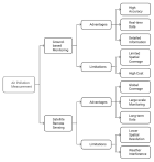
Figure 2

Figure 3
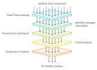
Figure 4
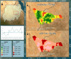
Figure 5

Figure 6

Figure 7

Figure 8

Figure 9

Figure 10
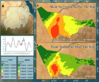
Figure 11

Figure 12

Figure 13
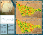
Figure 14

Figure 15

Figure 16
Similar Articles
-
A hybrid deep learning model to forecast air quality data based on COVID-19 outbreak in Mashhad, IranMaryam Zare Shahne*,Amir Sezavar,Fatemeh Najibi. A hybrid deep learning model to forecast air quality data based on COVID-19 outbreak in Mashhad, Iran. . 2022 doi: 10.29328/journal.acee.1001035; 6: 019-025
-
Air Quality Dynamics in Sichuan Province: Sentinel-5P Data Insights (2019-2023)Hossam Aldeen Anwer and Abubakr Hassan*. Air Quality Dynamics in Sichuan Province: Sentinel-5P Data Insights (2019-2023). . 2024 doi: 10.29328/journal.acee.1001068; 8: 057-062
-
Satellite-Based Analysis of Air Pollution Trends in Khartoum before and After the ConflictHossam Aldeen Anwer*,Abubakr Hassan,Ghofran Anwer. Satellite-Based Analysis of Air Pollution Trends in Khartoum before and After the Conflict. . 2025 doi: 10.29328/journal.acee.1001074; 9: 001-011
Recently Viewed
-
Do Fishes Hallucinate Human Folks?Dinesh R*,Sherry Abraham,Kathiresan K,Susitharan V,Jeyapavithran C,Paul Nathaniel T,Siva Ganesh P. Do Fishes Hallucinate Human Folks?. Arch Food Nutr Sci. 2017: doi: 10.29328/journal.afns.1001003; 1: 020-023
-
Assessment of Redox Patterns at the Transcriptional and Systemic Levels in Newly Diagnosed Acute LeukemiaAna Carolina Agüero Aguilera, María Eugenia Mónaco, Sandra Lazarte, Emilse Ledesma Achem, Natalia Sofía Álvarez Asensio, Magdalena María Terán, Blanca Alicia Issé, Marcela Medina, Cecilia Haro*. Assessment of Redox Patterns at the Transcriptional and Systemic Levels in Newly Diagnosed Acute Leukemia. J Hematol Clin Res. 2024: doi: 10.29328/journal.jhcr.1001029; 8: 017-023
-
Assessment of Indigenous Knowledge on Using of Traditional Medicinal Plants to Cure Human Diseases in South Omo Zone Baka Dawla Ari District, Kure and Bitsmal South EthiopiaGizaw Bejigo*. Assessment of Indigenous Knowledge on Using of Traditional Medicinal Plants to Cure Human Diseases in South Omo Zone Baka Dawla Ari District, Kure and Bitsmal South Ethiopia. J Plant Sci Phytopathol. 2024: doi: 10.29328/journal.jpsp.1001132; 8: 048-054
-
Nanoencapsulated Extracts from Leaves of Bauhinia forficata Link: In vitro Antioxidant, Toxicogenetic, and Hypoglycemic Activity Effects in Streptozotocin-induced Diabetic MiceBárbara Verônica Cardoso de Souza, Alessandra Braga Ribeiro*, Rita de Cássia Meneses Oliveira, Julianne Viana Freire Portela, Ana Amélia de Carvalho Melo Cavalcante, Esmeralda Maria Lustosa Barros, Luís Felipe Lima Matos, Tarsia Giabardo Alves, Maria. Nanoencapsulated Extracts from Leaves of Bauhinia forficata Link: In vitro Antioxidant, Toxicogenetic, and Hypoglycemic Activity Effects in Streptozotocin-induced Diabetic Mice. Arch Pharm Pharma Sci. 2024: doi: 10.29328/journal.apps.1001063; 8: 100-115
-
GELS as Pharmaceutical Form in Hospital Galenic Practice: Chemico-physical and Pharmaceutical AspectsLuisetto M*,Edbey Kaled,Mashori GR,Ferraiuolo A,Fiazza C,Cabianca L,Latyschev OY. GELS as Pharmaceutical Form in Hospital Galenic Practice: Chemico-physical and Pharmaceutical Aspects. Arch Surg Clin Res. 2025: doi: 10.29328/journal.ascr.1001084; 9: 001-007
Most Viewed
-
Evaluation of Biostimulants Based on Recovered Protein Hydrolysates from Animal By-products as Plant Growth EnhancersH Pérez-Aguilar*, M Lacruz-Asaro, F Arán-Ais. Evaluation of Biostimulants Based on Recovered Protein Hydrolysates from Animal By-products as Plant Growth Enhancers. J Plant Sci Phytopathol. 2023 doi: 10.29328/journal.jpsp.1001104; 7: 042-047
-
Sinonasal Myxoma Extending into the Orbit in a 4-Year Old: A Case PresentationJulian A Purrinos*, Ramzi Younis. Sinonasal Myxoma Extending into the Orbit in a 4-Year Old: A Case Presentation. Arch Case Rep. 2024 doi: 10.29328/journal.acr.1001099; 8: 075-077
-
Feasibility study of magnetic sensing for detecting single-neuron action potentialsDenis Tonini,Kai Wu,Renata Saha,Jian-Ping Wang*. Feasibility study of magnetic sensing for detecting single-neuron action potentials. Ann Biomed Sci Eng. 2022 doi: 10.29328/journal.abse.1001018; 6: 019-029
-
Pediatric Dysgerminoma: Unveiling a Rare Ovarian TumorFaten Limaiem*, Khalil Saffar, Ahmed Halouani. Pediatric Dysgerminoma: Unveiling a Rare Ovarian Tumor. Arch Case Rep. 2024 doi: 10.29328/journal.acr.1001087; 8: 010-013
-
Physical activity can change the physiological and psychological circumstances during COVID-19 pandemic: A narrative reviewKhashayar Maroufi*. Physical activity can change the physiological and psychological circumstances during COVID-19 pandemic: A narrative review. J Sports Med Ther. 2021 doi: 10.29328/journal.jsmt.1001051; 6: 001-007

HSPI: We're glad you're here. Please click "create a new Query" if you are a new visitor to our website and need further information from us.
If you are already a member of our network and need to keep track of any developments regarding a question you have already submitted, click "take me to my Query."


